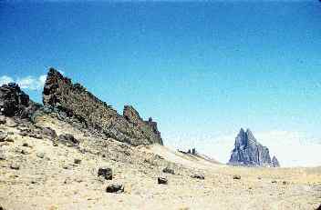
Volcanic LandscapesLandscapes created by volcanism contain a unique set of landforms. As volcanic activity subsides, magma may cool in the central vent and, over thousands of years, the overlying cone is worn away to expose the harden rock inside called a volcanic neck. Radiating away from the central vent may be nearly vertical fractures into which magma can intrude and cool. Erosion of the overlying surface reveals a linear, fin-like ridge radiating away from the volcano called a dike. Shiprock, New Mexico, is an example of a volcanic neck with prominent dikes radiating away from it. In Earth's geologic past, large areas have been inundated by massive floods of basaltic lava. A flood basalt of 170,000 cubic kilometers known as the Columbia River basalts covered a large portion of southeastern Washington, eastern Oregon and southern Idaho. The outpouring of 1100º C lava raced across the surface at an estimated average speed of 5 km/hour. When the eruptions ceased, over 500,000 km2 of the Earth's surface was covered. As streams carved the massive accumulation of lava, a lava plateau formed that we today call the Columbia Plateau. |
|
|
Figure 16.15 Shiprock, New Mexico in background with dikes in left foreground. Source USGS DDS21 |
Figure 16.16 View of the Columbia River and the Columbia River basalts that comprise the Columbia Plateau. (Courtesy USGS CVO) Click image to enlarge |
|
|
|