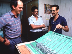
Models in GeographyA model is simply a representation of a real thing. You have seen and used models in the past, like a globe which is a model of the earth. Geographers construct models to analyze geographic processes because the real object of study may be too large to examine, the processes which created it operate over too long of a time frame, or experimentation might actually harm or destroy it. For instance, physical geographers construct physical models like stream tables to investigate the impact of hydrological processes on the earth. A stream table is more or less like a shallow sink filled with earth material similar to the land surface of interest. Water is applied to the material to see what effect varying amounts of water have on the erosion of the surface. Models may be simple conceptual models such as a box and arrow diagram showing the flows of energy between compartments of an ecosystem. Climate scientists use elaborate mathematical or numerical models. These could be complex numerical statements programmed into a computer model representing the impact of increasing carbon dioxide content of the atmosphere on global temperature.
Figure 1.27 Soil Scientists examine model of plots to investigate soil erosion (Source: Ben Nichols, U.S.D.A. Natural Resources Conservation Service)
Video: Climate in a Box |

