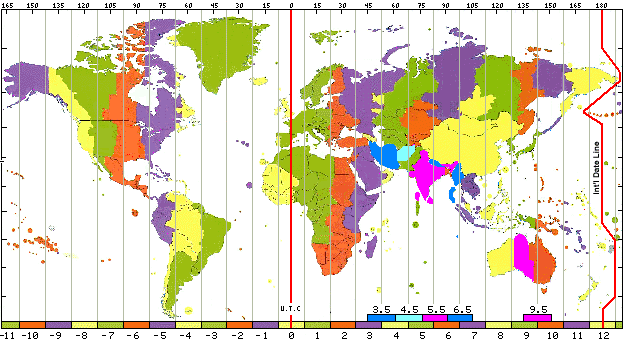
TimeEarly agricultural societies found that local noon could be determined by observing the changing length of the shadow cast by a stick placed placed perpendicular to the ground. Local noon is the time at which the shadow is the shortest length cast. Romans used this principle to design their sundials and called their noon position of the Sun the "meridian" (meridiem - the Sun's highest point of the day). It was difficult to compare time as one traveled to different localities as each city adjusted its clocks to their own local noon. Because the Earth rotates toward the east, towns to the east experienced solar noon earlier while those to the west later. Standard timeAs cross-country travel and communication became faster and more efficient, a standardized system of global time was required. Given the Earth rotates once throughout a 24 hour period, 24 standard times zones were agreed upon at the 1884 International Prime Meridian Conference. The local solar time at Greenwich, England was designated the prime meridian. Each time zone extends 7.5o on either side of a central meridian. For years the global standard for reporting time was Greenwich mean time (GMT). GMT is now referred to as Universal Time Coordinated (UTC) or Coordinated Universal Time but the prime meridian is still the reference for standard time. It uses the 24-hour time (military) notation based on the local standard time at the prime meridian of 0o longitude. Midnight corresponds to 00:00 UTC and noon to 12:00 UTC. (For more conversions, see Table 1.3 UTC Conversion Table)
Figure 1.40 UTC zones International Date LineFerdinand Magellan and crew in 1519 set out on their westward journey from Spain to circumnavigate the Earth. Upon their return three years later, they discovered that their meticulously kept logs were off by one day. This was one of the first recorded experience with changing global time. This earlier experience would ultimately lead to the establishment of the international date line. The International Date Line is an imaginary line the separates one day from another. It roughly follows the 180osup> meridian form the North Pole to the South Pole through the Pacific ocean, deviating around some territories. Crossing the line when traveling east one turns their calendar back a full day. Traveling west one moves their calendar forward one day. The Prime Meridian lies opposite of the International Date Line. Daylight Saving TimeMany countries observe daylight saving time - the practice of setting clocks forward one hour in the spring and back one hour in the fall. First proposed by Benjamin Franklin, the notion of extending daylight one hour into the evening didn't catch hold until World War One as a means of energy savings. Some countries,territories, and states in the U.S. do not observe daylight saving time. |