Drainage Patterns
Over time, a stream system achieves a particular drainage
pattern to its network of stream channels and tributaries as
determined by local geologic factors. Drainage patterns or nets are classified on the basis of their form
and texture. Their shape or pattern develops in response to the local
topography and subsurface geology. Drainage channels develop where
surface runoff is enhanced and earth materials provide the least
resistance to erosion. The texture is governed by soil infiltration, and
the volume of water available in a given period of time to enter the surface. If the soil has only a moderate infiltration capacity and a
small amount of precipitation strikes the surface over a given period of
time, the water will likely soak in rather than evaporate away. If a
large amount of water strikes the surface then more water will
evaporate, soaks into the surface, or ponds on level ground.
On sloping
surfaces this excess water will runoff. Fewer drainage channels will
develop where the surface is flat and the soil infiltration is high
because the water will soak into the surface. The fewer number of
channels, the coarser will be the drainage pattern.
Figure 18.5 Dendritic drainage pattern A dendritic drainage pattern is the most common form
and looks like the branching pattern of tree roots. It develops in regions underlain by homogeneous material. That is, the
subsurface geology has a similar resistance to weathering so there is no apparent
control over the direction the tributaries take. Tributaries joining
larger streams at acute angle (less than 90 degrees).
Parallel drainage patterns form where there is a
pronounced slope to the surface. A parallel pattern also develops in
regions of parallel, elongate landforms like outcropping resistant rock
bands. Tributary streams tend to stretch out in a parallel-like fashion
following the slope of the surface. A parallel pattern sometimes indicates the
presence of a major fault that cuts across an area of steeply folded
bedrock. All forms of transitions can occur between parallel,
dendritic, and trellis patterns.
Trellis drainage
patterns look similar to their namesake,
the common garden trellis. Trellis drainage develops in folded
topography like that found in the Appalachian Mountains of North America.
Down-turned folds called synclines form valleys in which resides the main
channel of the stream. Short tributary streams enter the main channel at
sharp angles as they run down sides of parallel ridges called anticlines.
Tributaries join the main stream at nearly right angles.
Figure 18.8 Rectangular Drainage Pattern The rectangular drainage pattern is found in regions that have undergone faulting. Streams follow the path of least resistance and thus are concentrated in places were exposed rock is the weakest. Movement of the surface due to faulting off-sets the direction of the stream. As a result, the tributary streams make sharp bends and enter the main stream at high angles. View an offset stream along the San Andreas Fault in Google Earth.
The radial drainage pattern develops around a central
elevated point. This pattern is common to such conically shaped features
as volcanoes. The tributary streams extend the headward reaches upslope
toward the top of the volcano.
The centripetal drainage pattern is just the opposite of the radial as streams flow toward a central depression. This pattern is typical in the western and southwestern portions of the United States where basins exhibit interior drainage. During wetter portions of the year, these streams feed ephemeral lakes, which evaporate away during dry periods. Salt flats are created in these dry lake beds as salt dissolved in the lake water precipitates out of solution and is left behind when the water evaporates away.
Deranged or contorted patterns develop from the disruption
of a pre-existing drainage pattern. Figure 18.11 began as a dendritic
pattern but was altered when overrun by glacier. After receding, the
glacier left behind fine grain material that form wetlands and deposits
that dammed the stream to impound a small lake. The tributary streams
appear significantly more contorted than they were prior to glaciation.
|
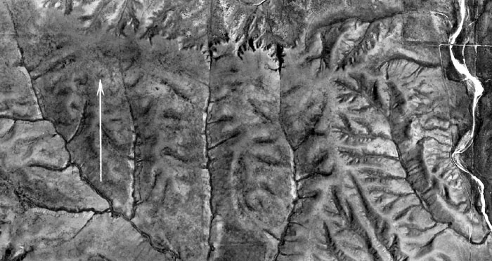
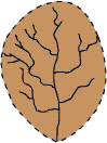
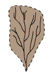 Figure 18.6 Parallel drainage pattern
 Figure 18.7 Trellis Drainage Pattern
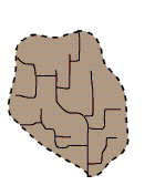
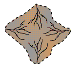 Figure 18.9 Radial Drainage Pattern
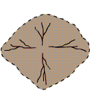 Figure 18.10 Centripetal Drainage Pattern
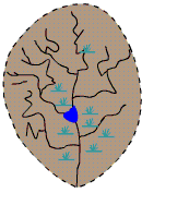 Figure 18.11 Deranged Drainage Pattern
