Landforms of Continental GlaciationExamine the diagrams of a
region
presently glaciated and the
same
region after glaciation while reading the material below. Figure 19. 8 Aerial photo of a portion of the Northern Unit of Kettle Moraine, WI. The rugged terrain and kettle lakes of the moraine is visible in much of the photograph. Moraines often take
the form of a belt of low hills composed of till. Where the snout, or leading edge of the glacier
was located a terminal
or
end moraine
can be found. The terminal moraine marks the furthest advance the ice
sheet. Behind the terminal moraine is found a
recessional moraine
deposited when the ice sheet receded and stopped for a period of time.
Often, uplands will cause an ice sheet to separate into lobes.
Interlobate moraines form between lobes of the ice sheet.
Ground
moraine is till that was lodged beneath the glacier and
generally found behind the terminal moraine. Ground moraine . Wetland areas are often
created in ground moraine which is a convenient way of identifying them
from a topographic map.
An outwash plain forms ahead of the terminal moraine as melt water from the snout of a glacier deposits stratified drift. The outwash plain is a relatively flat surface that may be pock marked with depressions called kettles. If numerous kettles are present the surface is called a pitted outwash plain.
Figure 19.10 Sinuous form of an is easily seen in this aerial
photograph Eskers are sinuous ridges of glacio-fluvial material that form in
tunnels in the ice sheet. The sides of the tunnel act as part of the
channel for a melt water stream. As the glacier recedes, the support for
the stream is removed and the stream deposits its load into a long
ridge-like form. Eskers are good sources for sand and gravel, and many
of them have been destroyed by mining for these materials.
Drumlins are stream-lined hills that appear separately or in "swarms". Their formation is not well known but form by the deposition of till. As the ice rides over the till it is smoothed into an inverted spoon-shaped feature. The steep side faces the direction the ice sheet came from while the more gentle slope of the tail points toward the direction of ice flow.
Kames are steep mounds or conical hills composed of stratified drift of diverse origin. Kames form in holes in the ice where sediment accumulates and once the ice melts it leaves the heap of sediment behind.
Kettles are pits in the surface that may or may not be occupied by water. They form when an isolated block of ice is surrounded by till or stratified drift. After a period of time the ice block melts away leaving behind a hole in the surface. Kettles are often found embedded in moraines (hence the name for Kettle Moraine State Park in Wisconsin).
Go here to view kames and moraine topography in the Northern Unit of Kettle Moraine, Wisconsin (Caution - 1.13 MB QuickTime file). |
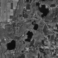

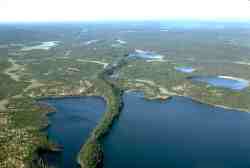
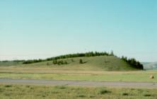 Figure 19.11 Streamline profile of a drumlin in Alberta, Canada
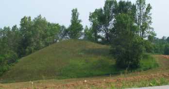 Figure 19.12 Kame in Kettle Moraine State Park, WI
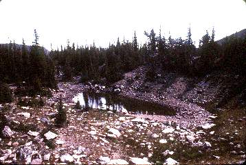 Figure 19.13 Kettle lake in moraine. (Courtesy USGS DDS21)