Digging Deeper: The Great East Japan Earthquake of 2011
On March 11, 2011 the Island of Japan was rocked by a violent earthquake. The magnitude 9 Tōhoku earthquake, officially named the Great East Japan Earthquake, originated 129 km (80 miles) offshore east of Sendai, Honshu, Japan, at a depth of 30 km. It was the fourth largest earthquake in the world since 1900. Honshu lies near the 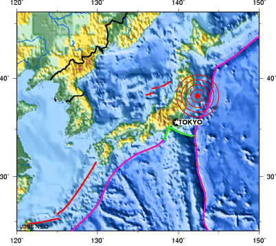 junction of the North American, Eurasian, Pacific, and Phillippine Sea plates. The massive earthquake radiated from plates slipping along the subduction zone, actually moving the entire country. Areas near Ishinomaki moved southeast by 5.3 meters (17 feet), while parts of Tokyo moved 9 inches.
Figure DD 15.1 Location of the Tōhoku earthquake. Courtesy USGS (Source)
As the North American plate slid upward over the Pacific plate, a 16 foot bulge of water rose and swept across the Pacific at an estimated 500 mph. As the water approached land the wave increased to incredible heights. A huge tsunami washed across the northern coast of Japan within moments. Sendai airport was inundated by a wall of water 12 m(39 ft) high. An estimated tsunami height of 37.9 m (124 ft) swept across the slope of a mountain 200 m (656 ft) from the coast. Flooded fields several kilometers inland remained so after more than a week due in part to coastal subsidence. Land subsidence at Oshika Peninsula Miyagi was as much as 1.2 m (3.93 ft). Those coast locations suffering from subsidence are now more susceptible to flooding during high tides.
Figure DD 15.2 Tōhoku earthquake tsunami propagation
Courtesy NOAA
The effects of the tsunami were far more deadly than the earthquake itself. Nearly 15,000 people were killed and 10,000 missing. Hundreds of thousands were left homeless as whole towns were devastated. The earthquake and subsequent tsunami severely damaged the Fukushima nuclear reactor station in the towns of Okuma and Futaba, leaking radioactivity into the air and water. Large evacuations of the surrounding area and contamination of food and water supplies resulted from the leakage.
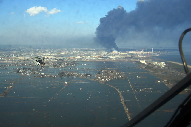
Figure DD 15.3 The flooded Port of Sendai, Japan.
Courtesy US Navy (Source)
Damage from the tsunami was not confined to Japan. Tens of millions of dollars in damage to public infrastructure and private property occurred in Hawaii. Along the west coast of North America docks and harbor facilities were damaged as a tsunami surge of up to 2.4 m (8 ft) struck portions of California and Oregon. An California man attempting to photograph the rising water was swept out to sea and died.
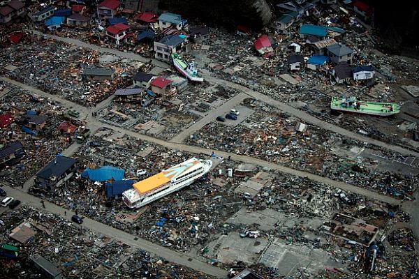
Figure DD 15.4 Achi, Japan. Large ferry boat washed ashore sits amid the ruins of houses.
Courtesy US Navy (Source)
