Global Patterns of Precipitation.As we are well aware, moisture availability from precipitation is unequally distributed across the Earth. The geographic pattern of precipitation is explained by examining the spatial distribution of air masses, water availability through evaporation, and uplift mechanisms. One of the most important climate elements is the influence of the global pressure systems.
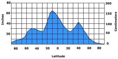
Figure 7.33 Latitudinal distribution of precipitation. Precipitation near the equator is high due in part to the influence of the Intertropical Convergence Zone. Here, convection and low pressure dominate and provide lift for the air throughout much of the year. At about 30o north and south latitude precipitation decreases due to the presence of the subtropical high pressure systems. Subsiding air from high pressure suppresses uplift which inhibits the formation of precipitation. Precipitation increases in the midlatitudes where vastly contrasting air masses collide along weather fronts to cause precipitation. As one approaches the poles, precipitation decreases on account of the cold temperature and its associated low saturation point. This is obviously a gross exaggeration of the true geographical distribution of precipitation. Orientation of winds, mountain systems, and air mass dominance play important roles in the pattern of precipitation. What is missing from our description is the temporal variation of precipitation over the Earth.
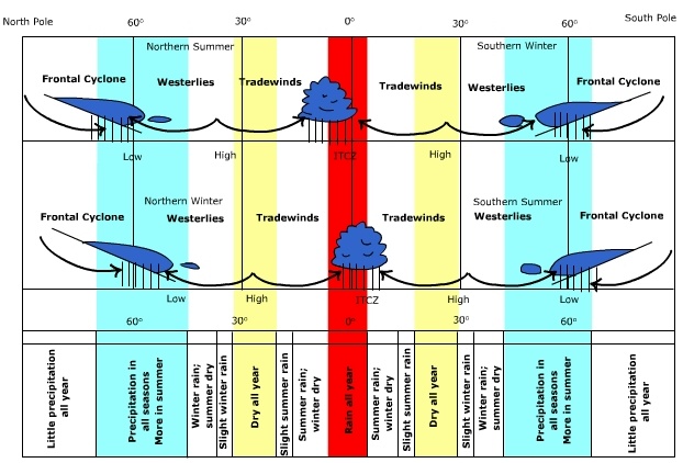
The temporal variation in global precipitation is directly linked to the seasonal changes in the heating of the Earth and its effect on the movement of global pressure systems and air masses. The migration of the ITCZ across the Equator keeps this region very moist. As one moves poleward, the precipitation becomes more variable as the drying effect of the subtropical is experienced. A dry region is found near 20 degrees of latitude as a result of the subtropical high. The north - to - south shifting creates summer dry climates poleward of the subtropical high but summer wet - to the equator ward side. Once into the midlatitudes, frontal activity keeps most seasons humid and moist. In the cold Arctic or Antarctic air little moisture is available for precipitation formation. The seasonal changes in precipitation are illustrated in the animation below. Areas of high precipitation coded in red and yellow are seen moving north and south during the year following the migration of global pressure and wind systems.
|