Future Geographies: Atmospheric Pressure and Winds
As we have seen in this chapter, the circulation of the atmosphere is largely a result of the unequal heating of the earth's surface. We should then expect changes in the patterns of air and ocean circulation as a result of changing temperature patterns due to future global warming.
Global Scale Pressure and Wind
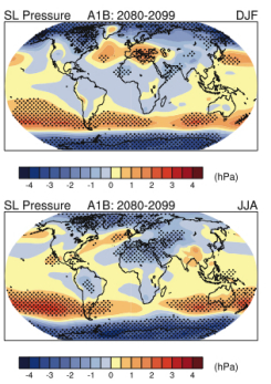
According to the Intergovernmental Panel on Climate Change, air pressure is to increase over the subtropics and midlatitudes, and decrease in the high-latitude regions of Earth. These changes will result from the poleward expansion and weakening of the Hadley Cell circulation and poleward migration of storm tracks causing an increase in cyclonic circulation patterns in the arctic and antarctic regions. The increase in high pressure will likely be accompanied by drier conditions in many parts of the subtropics and midlatudes. During the 1960s to the mid-1990s midlatitude westerly winds generally increased in both hemispheres which was accompanied by the poleward displacement of the Atlantic and southern polar front jet streams and enhanced storm tracks.
 Figure 6.25 Forecasted Changes in winter (top) and summer (bottom) air pressure. Courtesy IPCC (Source)
The location of jet streams are strongly tied to horizontal temperature gradients. If these temperature gradients change as a result of global warming, we should expect jet streams and the storms that track along them to shift as well. Recent research seems to indicate that this is occurring. A 2008 research report from the Carnegie Institution’s Department of Global Ecology examined jet stream conditions in both northern and southern hemispheres over a 23-year period from 1979 to 2001. They found that jet streams in both hemispheres have risen in altitude and shifted toward the poles. The jet stream in the northern hemisphere has also weakened. These changes fit predictions from global warming climate models and have drastic implications for the frequency and intensity of storms systems and patterns of precipitation that will reverberate through the earth system.
El Niño/La Niña
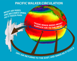
 Figure 6.26 Walker Circulation Loop Courtesy NOAA (Source)
The future impact of global warming on El Niño/La Niña is less certain. Recent research by the National Atmospheric and Oceanic Administration has found a 3.5% weakening in the Walker Circulation and hence tradewinds since the mid-1800s. The slowing trend appears to have intensified since the 1940s and larger than what is expected from natural climate variability. The only way to account for the observed changes was through the impact of human activity, primarily the effects of greenhouse gases from fossil fuel burning. A further 10% weakening is expected over the next 100 years. These changes point to a future climate more like that associated with El Niño.
The Monsoon
Global warming projections indicate a more rapid increase in temperature over land than over the oceans. Continental-scale land/sea temperature gradients will be larger during summer and smaller during the winter suggesting a weaker winter and stronger summer monsoon. Model predictions indicate a more complex pattern of potential effects. Some show a weakening of the Asian summer monsoon circulations as the temperature contrast between the continent and ocean decreases. The changing pressure patterns will impact the amount and intensity of precipitation during the summer and winter monsoon. This is taken up in "Future Geographies: Global Precipitation Patterns".
Local winds
Global warming is likely to have an impact on local scale winds as well. Using regional climate models, geoscientists have shown that as land/sea temperature contrasts increase in the future, strengthening of land/sea breezes is expected to occur. Results show an increase of 2 meters per second increase, a substantial impact given the current 5 meter per second average wind speed along the west coast of the United States. Strengthening onshore winds could enhance upwelling of nutrient-rich coastal waters, but the risk of wind-whipped wild fires increases as well.

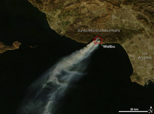
Figure 6.27 Smoke from 2007 Malibu, CA fire is blown out to sea by strong Santa Ana winds. Courtesy NASA EOS (Source)
Global warming may decrease the risk of severe Santa Ana conditions. The most severe conditions occur when a large dome of high pressure builds over the high desert of the Great Basin. Winds are whipped into a frenzy when cold air is adiabatically warmed as it spills down and through mountain passes. The air is then drawn into low-pressure areas off the coast near Los Angeles, CA. With global warming, the land heats more quickly during the fall and early winter, thus the dampening the temperature forcing of the Santa Ana winds.
Assess you basic understanding of the preceeding material by "Looking Back: Patterns Aloft, Ocean Circulation, and Future Geographies" or skip and continue reading.
