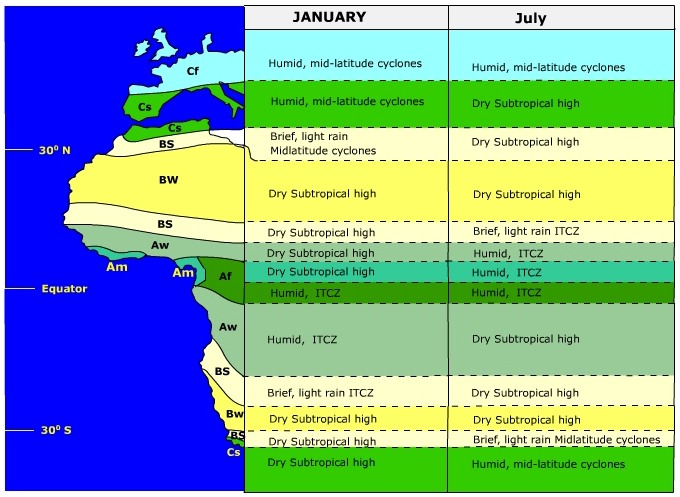
Global Pressure Patterns, Precipitation, and ClimateGlobal pressure systems play a direct role in the geographic distribution of precipitation. This influence is especially apparent in the relationship between pressure patterns and the distribution of precipitation and climate in Africa. For the most part, there is a horizontal pattern of climates stretching from the equator to poleward of 30o N related to the location of the Intertropical Convergence Zone (ITCZ), the semi-permanent Subtropical High (STH), and cyclones of the midlatitudes. Starting at the equator are the rainiest climates on earth, the tropical rain forest (Af) and tropical monsoon (Am). The tropical rain forest is noted to for its high, year-round rain fall that often exceeds 100 inches in a year. The copious rainfall is a product of the warm moist air masses that converge into the low pressure belt that straddles the equator and uplifted by convection. The monsoon climate in Africa, like the Asian monsoon, has a notable dry period during the low sun season. The dry period is due to the presence of the subsiding air of the subtropical high, while the wet season is due to the presence of the ITCZ and moisture-bearing trade winds along the coast.
Poleward of the monsoon and rain forest climates is the Tropical Wet/Dry climate (Aw) often called the "Savanna" climate. Like the monsoon climate, precipitation is seasonal though the Tropical Wet/Dry climate receives much less on an annual basis. During the low sun season, it is dominated by the STH producing extremely dry conditions. The savanna climate is considered a transitional climate between the rainy tropical and dry tropical climates. The Tropical Steppe climate (BS) is dominated by the STH for much of the year, though it does receive brief high-sun season rains as the ITCZ migrates into this region. The Tropical Steppe climate is considered a semi-arid climate with enough precipitation to support drought resistant grasses but not for trees. Poleward of the steppe is the Tropical Desert Climate (BW). The tropical desert climate is the driest on Earth that in some locations has virtually no measurable precipitation on an annual basis. The extreme aridity is due in part to the year-round dominance of the subtropical high. At about 30o north latitude we encounter another zone of tropical steppe climate. Though the climatic conditions are the same, the seasonal dominance of pressure systems has reversed. During the high sun season the STH moves into this region to create dry conditions. During the winter, cyclones spawned in the midlatitudes slip into the steppe climate to bring sporadic and brief rain showers. Finally, we reach the Mediterranean Sea where we find the Dry Summer Subtropical Climate (Cs), or sometimes called the "Mediterranean Climate". Like the steppe climate on its equatorward border, it has a dry summer/wet winter precipitation regime. However, the region receives more precipitation on an annual basis than its neighboring steppe climate. To learn more about the effects of atmospheric circulation on our environment, proceed by: "Digging Deeper: Atmospheric Circulation and Air Quality" or continue to the next topic.
Assess your basic understanding of the preceeding material by "Looking Back: Local, Regional, and Global Circulation" or skip and continue reading. |

