Chapter 6
Atmospheric and Ocean Circulation

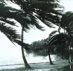
Hurricane-generated waves break on sea wall
Courtesy NOAA
The atmosphere around us is in constant motion, even if we don't feel the wind across our face. Molecules of air dart about transferring heat and moisture from one place to the next at a variety of geographic scales. The animation below shows the wind pattern over North America during 1988 when this region experience a severe drought. Winds are show at three heights, the blues arrows at 9,300 meters (30,000 feet), white arrows at 5,500 meters, and black (18,000 feet) and 1,500 meters (5,000 feet). Watch the animation by clicking the play button and describe what you see.
One feature that stands out is a zone of winds making broad loops along the boundary between the United States and Canada. One can see the arrow moving much faster through this zone from the west than other regions. Why does this region of high velocity winds occur here and what are the implications of its meandering path? Is this a typical wind pattern or could it change in the future?
In this chapter you will learn how winds at a variety of spatial scales form and what controls their behavior. You'll look at how atmospheric pressure and wind patterns influence weather and climate. Finally you will delve into what causes oceanic circulation and how it relates to atmospheric motion.
Learning Outcomes:
By the end of the chapter you should be able to:
- Define air pressure and what determines air pressure at a place.
- Describe the forces acting on wind and how they affect wind direction and speed.
- Interpret the strength of a pressure gradient from a weather map.
- Determine wind speed and direction from a weather map.
- Draw a diagram of the air flow around highs and lows in the Northern and Southern hemispheres.
- Explain the relationship between upper-air circulation and surface pressure systems.
- Explain how land/sea breeze, mountain/valley, and Santa Ana winds form.
- Explain how the monsoon circulation operates.
- Describe how El Nino/La Nina conditions form and their effects.
- Construct a diagram and label the global pattern of pressure and wind.
- Describe the potential impact of global warming on atmospheric circulation.
See if you are prepared for this chapter by Getting Ready for Chapter 6: Atmospheric and Oceanic Circulation.
You may view a list of chapter topics by clicking the "Topic Outline" link or go directly to the first topic by clicking "Continue".
Previous | Topic Outline | Continue
