Tropical Wet/Dry (Savanna) Climate
The Tropical Wet/Dry climate is located on the poleward sides of the tropical wet climates, positioned between them and the tropical dry climates. This location places the climate at an intermediate position between the ITCZ and the Subtropical High. As a result, the climate experiences a distinct seasonality to its precipitation like that of the tropical monsoon climate. Also known as the "Savanna" climate, it supports a ground cover of drought resistant grasses with scattered trees, but not enough rainfall to make agriculture a viable, life sustaining activity. Geographical LocationThe Tropical Wet/Dry climate lies at latitudes of about
5o
- 10o and 15o - 20o. Broad expanses of
the savanna exist in north and south central Africa, The Llanos of Venezuela, Campos of Brazil, much of northern and eastern India, western
Central America, the Caribbean
Islands, and south Florida, Myanmar (Burma) and
the Indo-Chinese Peninsula Figure 9.7 Climograph for Dakar, Senegal Controlling FactorsIts position at about 15o North or South latitude places the Tropical Wet/Dry climate in a zone between the alternating influence of the Intertropical Convergence Zone (wet season) and the (dry season) subtropical high. The subsidence of the subtropical high suppresses precipitation, creating clear skies allowing much insolation to the surface. Converging air into the ITCZ, in combination with convection, forces air to rise, causing condensation, cloud development, and precipitation. Distinguishing CharacteristicsTemperatureLocated at a higher latitude, the variation in insolation is greater and hence this climate has a larger annual temperature range than the other tropical wet climates. However, the average annual temperature is similar to that of the other tropical wet climates. Mean monthly temperatures in the Tropical Wet/Dry climate range from 18oC (64.4oF) to above 25oC (77oF). Like the monsoon climate, the maximum temperature tends to occur in late spring to early summer prior to the onset of the rainy season. There may be a secondary maximum after the rainy period. Annual temperature ranges increase as one moves poleward through the climate. Daily temperature ranges are greatest during the dry season and a bit larger than the rainy tropical climates. Diurnal temperature ranges of 10oC to 15oC during winter are not uncommon. During the summer, high daily temperatures, small temperature ranges, and high humidity create the same uncomfortable conditions as those found in the rainy tropics. Precipitation
The Tropical Wet/Dry climate is the driest of the tropical wet climates. Like the monsoon climate, it has a distinct seasonality to its precipitation. However, its wet season is much shorter and receives far less precipitation than the monsoon climate. The seasonality of precipitation is related to the migratory movement of the ITCZ and Subtropical High. During the high sun season the ITCZ dominates, causing convergent uplift, along with the ever-present convection to promote the production of precipitation. During this period, warm and moist mE and mT air masses dominate. During the low sun season the ITCZ moves out and the subtropical high moves in suppressing precipitation and initiating the long drought period. The exceedingly warm and dry cT air masses dominate during this time of the year. Variability of precipitation makes it very difficult for agriculture. Nairobi, Kenya averages 86 cm (33.9 in) of rainfall, but from year-to-year can vary from 50 (9.7 in) to 150 cm. (59 in) The drier the savanna location, the more unreliable the precipitation. Rains are essential in greening the savanna, and animals migrate with the seasonal rhythms in search of water and pasture.
The most famous of these migratory journeys is that of the wildebeest. Rains fall unevenly in the Serengeti and the southeast section dries out more quickly than the northwest. By May the grasses have been chewed low, forcing its inhabitants to seek greener pastures. A million wildebeests accompanied by zebras and gazelle, merging and splitting into columns several kilometers long begin an arduous trek towards better feeding grounds in the northwest. During the headlong rush northward, they plunge across rivers in such numbers and concentrations that many of them drown. More are forced into the water by the pressure from the multitude of wildebeest approaching from behind. Predators ambush them and pick off exhausted and sick animals with ease. After a torturous 200 kilometers or so, they reach the still lush pastures of the Mara in southern Kenya. There they will stay and feed until November when the rains return. |
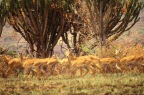 Figure 9.6 Impala on the Savanna.
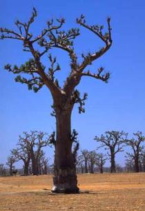 Figure 9.7 A Baobab tree, with its thick trunk and large edible fruit,
Dakar, Senegal.
Figure 9.7 A Baobab tree, with its thick trunk and large edible fruit,
Dakar, Senegal.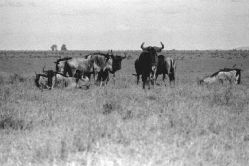 Figure 9.8 Wildebeest
in Masailand,
Kenya
Figure 9.8 Wildebeest
in Masailand,
Kenya