Dig Deeper into Locational Systems: United States Public Land Survey (USPLS)Latitude and longitude gives us an easy way of locating points on the Earth. Instead of a point, we may wish to identify land areas. In the United States, the United States Public Land Survey (USPLS), conceived by Thomas Jefferson, is used to identify parcels of land. The USPLS is actually a means of describing parcels of land, but like latitude and longitude, the USPLS is basically a grid that can be used to identify location.
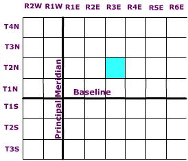
Across the United States, several principal meridians (lines of longitude) have been selected to define "columns" of ranges every six miles either east or west of a particular principal meridian. In a similar fashion, "rows" of townships are delimited every six miles either north or south of a particular baseline, that coincides with a line of latitude (Figure 1.14). This creates a grid work of townships and ranges encompassing 36 square miles in area. Actually, an individual cell in this grid is sometimes referred to simply as a township.
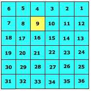
A township is subdivided into 36 1 square mile
sections. Sections are
numbered beginning at the upper right and working left to section 6,
then down to 7, and then right across to section 12 ending with 36 sections
as shown in Figure 1.15.
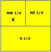
Each section is 640 acres in size and can be further subdivided into smaller units by either halving or quartering the section (Figure EG.16) and described according to direction. For instance, the letter X is located in the NW 1/4, S9, T2N, R3E.
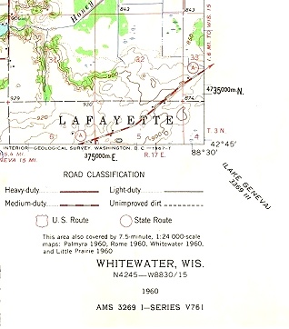
All United States Geological Survey topographic maps show the township, range, and section information on them. Figure EG.12 is a portion of the Whitewater, WI 1:24000 USGS topographic map. Township and Range information is found printed in red along the bottom and left margins (R 17E, T3N). Section boundaries are printed in red and their number designation is printed in the center of the section. Figure DD 1-H. USPLS coordinates on topographic map.
|
 Figure

This work is licensed under a Creative Commons Attribution-ShareAlike 4.0 International License..