Isolines
Isarithmic maps use isolines to depict the geographic pattern of earth phenomena. An isoline is a line that connects points of equal value. For instance, the brown contour lines on a topographic map connect points of equal elevation. Isobars are used to show the distribution of air pressure . Some common isolines encountered in physical geography are:
- isotherm: a line connecting points of equal temperature.
- isohyet: a line that connects points of equal precipitation
- isophene: a line representing points where biological events occur at the same time, such as cops flowering.
- isopleth: a line connecting points of equal numerical value, like population
- isotach: a line of equal wind speed.
- isobath: a line representing points of equal water depth.
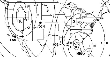
Figure 1.17 Isobars on a weather map depicting pressure pattern over United States
(Courtesy NASA)
A few "rules" apply to isolines. First, there is a set interval between consecutive isolines called the isoline interval. For example, the map in Figure 1.17 uses isobars to depict the disribution of air pressure. A 5 millibar interval was used to drawn them. Second, two different isolines cannot cross each other. If they did, it would mean two different values are at the same location. Third, values inside a closed isoline are either higher or smaller than those outside.
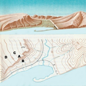
Figure 1.18 The land surface and how its depicted on a topographic map. (Courtesy USGS)
Because the interval between isolines is constant, their spacing gives an visual indication of the change that occurs over a given distance, called a gradient. The more closely spaced the isolines, the larger is the gradient. For example, the spacing of contour lines between A-B on the topographic map shows a much steeper hillslope gradient than does the spacing of the contour lines between points C-D.
