|
Fluvial
Systems
Landforms of Alluvial Rivers
Rivers that have reached base level develop broad
valleys by erosion caused by meandering channels. The stream channel
cuts through and redistributes its sediment or alluvium
that
lines the area bordering the stream.
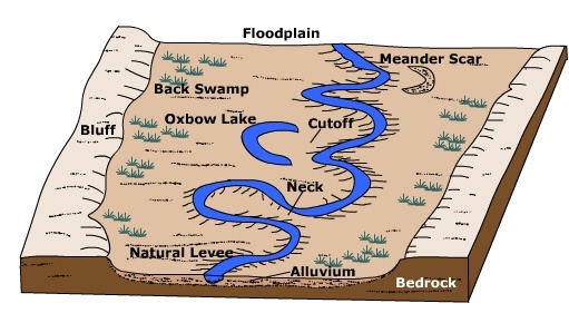
Figure 18.34 Alluvial Stream Features
Click on the name of a landform to jump to its description.
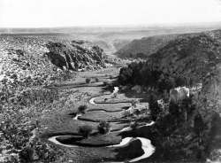
Figure 18.35 An alluvial river meanders through its floodplain
(Courtesy USGS DDS21)
A floodplain is the relatively flat area that borders
a stream which is periodically inundated with water during high flow
periods. When excess runoff causes the stream discharge to
increase beyond the capacity of the channel, water spills out onto the
floodplain. Increasing the cross-sectional area of stream flow causes a
decrease in stream velocity. The resulting decrease in velocity causes
sediment to deposit as
alluvium on the floodplain  .
These alluvial deposits are often rich in nutrients and thus naturally fertilize
floodplain soils. Floodplain agriculture has given rise to many of the
great world civilizations. .
These alluvial deposits are often rich in nutrients and thus naturally fertilize
floodplain soils. Floodplain agriculture has given rise to many of the
great world civilizations.
A natural levee
is an narrow ridge of alluvium deposited
at the side of the channel. During high discharge periods when the
stream floods, coarse sediment settles out near the stream channel and
grades to finer material further away. The over bank deposits of alluvium
are often rich sources of nutrients for soils developed on the floodplain. Because
floodplain soils are usually quite fertile, humans have inhabited them for
years. To prevent flooding, artificial levees are built close to the
channel, typically higher than natural levees. Confining the flood
discharge to a small area increases the velocity of flow. The levees
of the Mississippi River increase the flow velocity near the mouth as it
enters the Gulf of Mexico. As a result, sediment is shot into the Gulf
rather than being deposited near the mouth building the river's famous 'bird's foot'
delta.
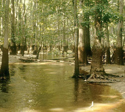 Figure 18.36 Draining back swamp of Roanoke River
Courtesy US FWS (Source) Figure 18.36 Draining back swamp of Roanoke River
Courtesy US FWS (Source)
Back swamps are located some distance away from the stream
channel on the floodplain. When water spills over onto the floodplain,
the heaviest material drops out first and finest material is carried a
greater distance. The fine grained alluvium holds much water and drains
rather slowly creating wetland areas. Back swamps are important
"sponges" that retain water that might cause severe flooding
downstream.
Previous | Continue
|
