A meander is a bend in a stream. Vertical channel
cutting is typical of the early stages of stream system evolution and hence,
meandering channel pattern is negligible. However during later stages as base
level is achieved and channel equilibrium is approached, lateral migration
of the stream channel is more prevalent. Meanders grow both laterally and in the
down stream direction. As water flows into a meander it takes on a helical or spiral
flow which determines where erosion and deposition is concentrated. Centrifugal
force draws water toward the outside bank (cut bank) causing erosion. Sediment
eroded from the outside bank is deposited on the inside bank and transported
downstream.
Figure 18.35 Point bars (white) and Bar and Swale Topography on an meandering channel
(Courtesy USGS DDS21) Click mage to enlarge
As water rounds a meander, the water swings toward the outside bank where erosion is
concentrated and then spirals toward the inside banks. As the water spirals
toward the inside of the meander it is slowed by frictional drag imposed by the
bed of the channel. This causes deposition of alluvium on the inside bank to
form a bar. A point bar forms on the inside bank of a meander
and rising from the channel as an accumulation of alluvium. As the channel meander continues to erode laterally, a succession of
bars with intervening swales form called bar and swale
topography.
A neck is the upland between opposing
meanders of a stream. A cutoff occurs when the neck between river
meanders is eroded away and the meanders join to shorten the length of
the channel. The slope of the channel increases as well when the river shortens
its length.
Mark Twain aptly described the process and effect of
river cutoffs when he wrote:
"The Mississippi is remarkable in another way--its
disposition to make prodigious jumps by cutting through narrow necks of
land, and thus straightening and shortening itself. More than once it
has shortened itself thirty miles at a single jump! These cut-offs have
curious effects: they have thrown several river towns into the rural
districts, and built up sand bars and forests in front of them. The town
of Delta used to be three miles below Vicksburg: a recent cutoff has
radically changed the position, and Delta is two miles above Vicksburg."
A river cut-off results in a portion of the river
isolated from the new channel called an oxbow lake.
Oxbow lakes
are typically crescent shaped - like that of an oxbow. Groundwater
seeping into the oxbow maintains the lake. Some oxbows will drain or silt up due
to deposition during floods. The remnants of the oxbow is identified as a
meander scar.
Wetland and marshes are often found in the scar.
Cut-off and Oxbow Formation on a Stream Table (Courtesy stevekny)
(A stream table is used to model and simulate stream flow.)
Please contact
the author for inquiries, permissions, corrections or other
feedback.
For Citation: Ritter, Michael E.
The Physical Environment: an Introduction to Physical Geography.
Date visited. https://www.earthonlinemedia.com/ebooks/tpe_3e/title_page.html
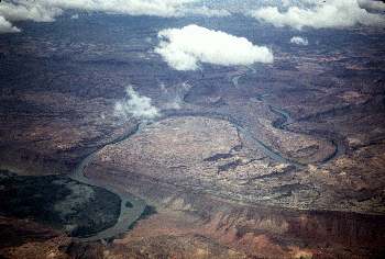 Figure 18.34 Meandering channel
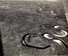 Figure 18.36 Oxbow lake (Courtesy USGS)