Stream GradationThe characteristics of a stream channel represents a
balance between the amount of water flowing through it, the material the
channel is located in, and the relief of the region in which the channel has
formed. The famous physical geographer William Morris Davis
The Davisian CycleAt the beginning of the youthful stage, the region in which the stream system forms has recently been uplifted. Water is concentrated into channel actively that cuts downward toward base level, the theoretical limit to which a stream can erode its channel. For streams entering the ocean, base level is sea level. For tributary streams, it is the elevation of the stream into which the tributary joins. During this early stage a maximum amount of relief is created with water falls, narrow channels, and little flood plain area beside the stream. Once the stream reaches base level, vertical cutting ends and horizontal erosion becomes predominate. During this "mature stage" the stream begins to cut away at the sides of the channel, creating a wider floodplain. The channel begins to meander, making broad bends along its length. As meandering channels wear away at interfluves, the surface is worn down to a plain of low relief called a peneplain. The landscape remains in its "old age" stage until uplift renews the cycle. Modern TheoriesModern theories of landscape development suggests that stream system development achieves a dynamic equilibrium between the system and its environment. The equilibrium state is determined by the balance between inputs and outputs from the system. Over time, the channel achieves an equilibrium state between inputs (water) and outputs (sediment). Once equilibrium is achieved it remains in this state until a disturbance alters the inputs and outputs of the stream system. The Graded StreamIn several cases throughout this book we have noted that natural open systems tend toward a state of equilibrium and stream systems are no different. Over a long period of time, the gradient of a stream adjusts so that the average load of sediment is balanced by that which it receives from surrounding slopes and in-flowing channels. For example, if sediment accumulates in stream, the bed of the channel is raised and the slope of the stream increases downstream of the deposit. Increasing the slope results in a higher stream velocity thus increasing the water's ability to move sediment. Eventually, a channel slope is reached that can carry away the accumulated sediment. Conversely, if sediment delivery to the stream is reduced, down cutting of the channel ensues. Channel erosion lowers the stream gradient until the material contributed to the stream is equal to that which is transported through it. Once a stream adjusts its gradient for the local environmental conditions is referred to as a graded stream.
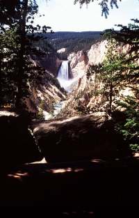
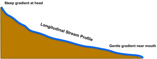
Figure 18.32 Longitudinal Stream Profile The longitudinal profile is a depiction of the down slope gradient of a stream. The longitudinal profile of a stream can reveal if a stream has achieved a graded state, whether over a part or the entire stream. The curved profile of a graded stream exhibits a steeper slope upstream giving way to a gentle slope in the down valley direction. Initially stream profiles may be irregular with the stream gradient interrupted by knickpoints where waterfalls are found. Knickpoints form where the stream flows over an exposure of resistant bedrock or from tectonic uplift. The knickpoints slowly wear down and migrate upstream as water spills over them. Through time the profile is smoothed to a gentle concave shape.
Figure 18.33 Channel bed erosion by upstream progressing knickpoint
|


