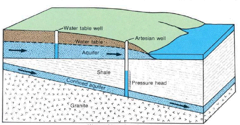
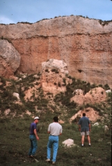
GroundwaterGroundwater occupies the zone of saturation. As depicted in the hydrologic cycle diagram, ground water moves downward through the soil by percolation and then toward a stream channel or large body of water as seepage. The water table separates the zone of saturation from the zone of aeration. The water table fluctuates with moisture conditions, during wet times the water table will rise as more pore spaces are occupied with water. Groundwater is found in aquifers, bodies of earth material that have the ability to hold and transmit water. Aquifers can be either unconfined or confined. Unconfined (open) aquifers are "connected" to the surface above. Confined (closed) aquifers are sandwiched in between dense impermeable layers of earth material called an aquiclude. Ground water is replenished by percolation of water from the zone of aeration downward to the zone of saturation, or in the recharge zone of a confined aquifer. The recharge zone is where the confined aquifer is exposed at the surface and water can enter it.
Figure 10.7 Unconfined and confined
aquifers Aquifers replenish their supply of water very slowly. The rate of groundwater flow depends on the permeability of the aquifer and the hydraulic gradient. Permeability is affected by the size and connectivity of pore spaces. Larger, better connected pore spaces creates highly permeable earth material. The hydraulic gradient is the difference in elevation between two points on the water table divided by the horizontal distance between them. The rate of ground water flow is expressed by the equation: Ground water flow rate = permeability X hydraulic gradient Groundwater flow rates are usually quite slow. Average ground water flow rate of 15 m per day is common. Highly permeable materials like gravels can have flow velocities of 125 m per day.
10.8 Ground water movement Groundwater in an aquifer is under pressure called hydrostatic pressure. Hydrostatic pressure in a confined aquifer pushes water upward when a well is drilled into the aquifer. The height to which the water rises is called the peizometeric surface. If the hydrostatic pressure is great enough to push the peizometeric surface above the elevation of the surface, water readily flows out as an artesian well.
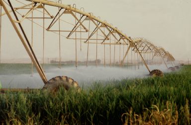
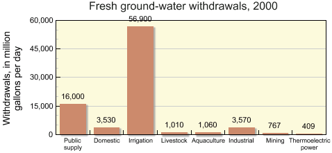
Figure 10. 9 Pivot irrigation on a barley field in Saudi Arabia. The barley is used as fodder for milk cows. (Source: F. Mattioli, FAO Used with permission) Groundwater and Human ActivitiesGroundwater is an important source of water for human activities such as agriculture and domestic drinking water. In 2000, 68% of fresh ground water was used for irrigation while another 19% was extracted for public-supply purposes, mostly drinking water. For those who supply their own water for domestic use, over 98 percent is from ground water.
Figure 10. 10 United States groundwater withdrawals (2000) Courtesy USGs In dry regions and in places where soils
are highly permeable, agriculture uses large amounts of ground water for irrigation.
The high rate of water use for agriculture has fueled tensions
between urban and rural interests. A Dec. 4, 1998 "Talk of
the Nation - Science Friday" segment, "San
Antonio: Water Rights", discusses the competing
demands of
urban and rural populations using the Edwards
Aquifer in south Texas.
However, the rate of groundwater removal by humans sometimes exceeds the recharge of the
aquifer. Such is the case of the High
Plains Aquifer of Arizona, Colorado, New Mexico, and Utah.
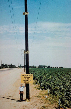
Over pumping of ground water reserves can lead to compaction and
degradation of the aquifer. As the water is removed, the aquifer
often collapses causing the surface to subside. Aquifer
compaction reduces pore space, making recharge more
difficult. One of the most striking examples is that which has
occurs in the San Joaquin Valley of California. An August 6, 2013 NPR All Things Considered segment An NPR Morning
Edition segment from July 2, 2013
Figure 10.12 Land subsidence in California
|