The Physical Environment
                                          Contents | Glossary | Atlas |  Index | TPE Today | Google Earth | Search

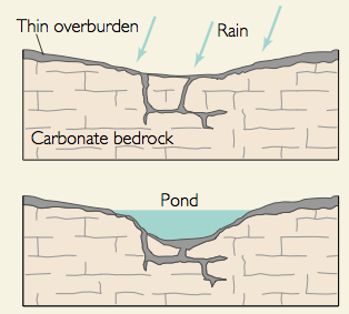
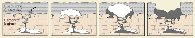
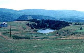
Weathering, Erosion, and Mass Movement

Karst Landscapes

The chemical weathering of carbonate-rich rocks creates a unique landscape abounding in caves, disappearing streams, and springs. Karst, a Yugoslavian term that comes from a narrow strip of limestone plateau noted for the assemblage of solution landforms. Karst develops in regions underlain by limestone and to a lesser extent dolomite. Chemical solution of the limestone, especially when fractured, wears away the bedrock leaving fissures and possibly undermining the surface. Some of the most spectacular cave complexes are found in such areas. Significant karst regions are found in Jamaica, the northern Yucatan,  New South Wales, northern Puerto Rico, the Great Valley Region of Pennsylvania, Maryland, Virginia, and Tennessee, central Kentucky and central Florida in the United States

Carlsbad Caverns
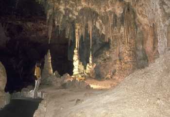
Figure 17.5 Stalactites hang from the ceiling and stalagmites grow from the floor of Carlsbad Caverns, NM (Photo Credit: National Park Service)

Generally four conditions are important for karst development. First, there must be limestone at or near the surface. Though karst is found in areas underlain by dolomite, it usually far less soluble than limestone. Second, the limestone must be dense, highly jointed, and thinly bedded. If the rock is too porous, water will be rapidly absorbed throughout the entire mass and not be concentrated along restricted flow lines.  Third, the existence of entrenched valleys below uplands underlain by soluble and well jointed rocks ensures downward movement of groundwater, favorable for the development of karst. Finally, at least moderate precipitation must fall in the region. Few arid or semi-arid regions exhibit karst features, though some relic features may exist from a previous moist period in the past.

Karst Landforms

One of the most common features of areas underlain by limestone are sinkholes. Sinkholes form either from beneath the surface or from the surface down. Collapse sinkholes form when the limestone is dissolved away from below, removing the support for the surface and it collapses in.  Collapse sinks can be particularly dangerous because one might not know that the support for the surface under their feet is being slowly eaten way. Sinkholes can also be created where water infiltrates into the surface widen the fissure into which it flows. These sinkholes are called dolines

Figure 17.6 Sinkholes from dissolution
Courtesy USGS


Sinkholes are commonly funnel-shaped and broadly open upward. They may be a few feet to more than 100 feet in depth, though usually ranging from 10 to 30 feet. Sinkhole diameter sizes range from a few square yards to several acres in area.

Figure 17.7 Collapse sinkhole
Courtesy USGS

Sinkhole

 Streams flowing along the surface may enter a sinkhole as a "disappearing stream" and flow underground for some distance to reappear at the surface. A karst window forms when the roof above the underground stream collapses in. Cavern systems are carved by these underground streams over time. 

Figure 17.8 Sinkhole, Cape Breton, Canada
Image courtesy Geological Survey Canada


Previous | Continue    


Contents |Glossary | Atlas Index  |  Blog | Podcast | Google Earth | Search Updates | Top of page

About TPE | Who's Used TPE |  Earth Online Media

Please contact the author for inquiries, permissions, corrections or other feedback.

For Citation: Ritter, Michael E. The Physical Environment: an Introduction to Physical Geography.
Date visited.  https://www.earthonlinemedia.com/ebooks/tpe_3e/title_page.html

Michael Ritter (tpeauthor@mac.com)
Last revised 6/5/12

Help keep this site available by donating through PayPal.

paypal

Creative Commons License
This work is licensed under a Creative Commons Attribution-ShareAlike 4.0 International License..