Chapter Review Assess your understanding of concepts related to this chapter by answering the questions below. Click the question to reveal the correct answer.
An air mass source region is one that has flat terrain and dominated by high pressure
Air masses are modified by the surface over which they travel. For example, an mT air mass that passes over a cold ocean current is chilled at the surface enhancing stability. Cold air masses traveling over warm surface are heated enhancing their instability.
A front is boundary between contrasting masses of air. They are a zone of converging air and lower pressure.
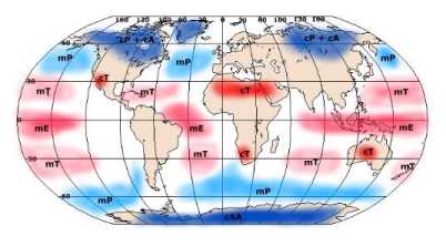
mP air masses are cool and moist forming over oceans at about 60o N and S. cP air masses are cold and dry forming over continents at about 60o N. mT air masses are warm and moist air masses forming over oceans at about 30o N and S. cT air are warm and dry air masses forming over continents at about 30o N and S. Cyclones form along frontal boundaries like the polar front where air is converging from opposite directions. A twisting motion is created as cyclonic shear takes place between the converging air streams. The surface convergence is supported by upper level divergence in the jet stream. The spiraling storm creates a cold front as cold air pushes into regions once occupied by warm air. A warm front is spawned where warm air intrudes into regions once dominated by cold air. Through time the cold front and warm front merge to form an occlusion. Finally the storm dissipates.
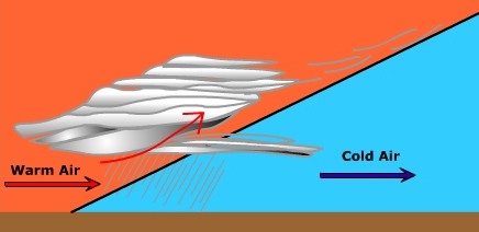
A change in cloud cover from cirrus, to cirrostratus, altostratus, and stratus is typical of the approach of a warm front. Air pressure decreases as the front approach, then increases after passage. Nimbostratus clouds are present along the warm front if it is precipitating. Low intensity/long duration precipitation is typical of nimbostratus clouds. Wind are likely to shift from an easterly direction to a southerly direction as the warm from passes. Air temperatures rise upon the passage of the front.
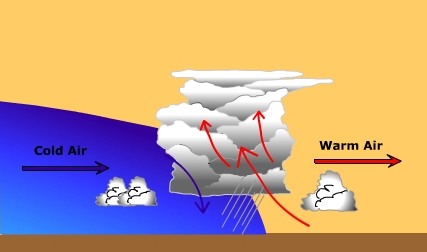
The air ahead of a cold front is generally from the south in the warm sector. Pressure drops as the front approaches. Cumulus clouds grow into cumulonimbus clouds and intense, but short-lasting precipitation occurs. As the front passes, wind shifts from a southerly/southwesterly direction toward the west and possibly northwest. Temperatures decrease as the front passes. After passage, cloud cover dissipates.
Precipitation along warm fronts tends to be low intensity and long in duration. Precipitation along cold fronts tends to be high intensity and short in duration.
Cumulus stage: Creation of a cumulus cloud by updrafts of warm, moist air Mature stage: Updrafts of warm moist air fuels the developing storm. Downdrafts of cold dry air is created by precipitation entrainment. Decay stage: Downdrafts predominate as uplift of warm moist air ceases. There is much we do not know about tornadoes. Tornadoes are most common during the Spring when greatly contrasting
air masses collide to produce severe storm systems. Wind shear within
the severe thunderstorm causes rotation of air about a
horizontal axis. The
rotating circulation is tilted into the vertical by
the updrafts in the thunderstorm. As the
rotating air increases in height and shrinks in size
a mesocyclone is formed. For whatever reason,
a tornado funnel is spawned within the mesocyclone.
A hurricane develops from a tropical disturbance once it reaches
sustained winds in excess of 75 mph (65 knots). Most hurricanes form
poleward of 10o latitude as the Coriolis effect is too
weak closer to the equator. Hurricanes form in a uniform mass of warm air over
tropical oceans with temperatures of 80o F (26.5o
C) through a depth of 200 feet (60 meters).
The high water level that precedes the hurricane called the "storm surge" creates the most damage due to flooding.
|