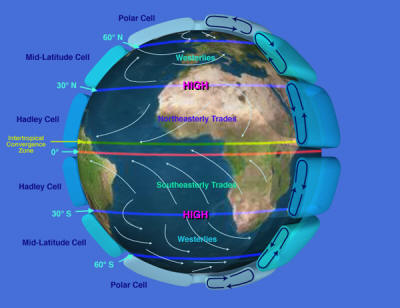
Global scale circulationThe circulation of air over the earth is largely due to the unequal heating of the surface. The global circulation of pressure and wind plays an integral role in the heat balance of the earth, as well as creating global ocean currents. The global circulation of the atmosphere transfers warm air from low latitudes towards high latitudes, and cold air from high latitudes towards low latitudes. This exchange keeps low latitude regions where there is a net gain of energy through the year from continually heating up and high latitudes from continual cooling due to a net loss of energy (see latitudinal variation in the radiation balance). Geographers often use a three-cell model to describe the basic features of Earth's global patterns of wind and pressure. The basic assumptions of the model are:
With these conditions on a rotating Earth, three circulation cells between the equator and the poles are predicted, the Hadley Cell between the equator and latitude 30o, the mid-latitude or Ferrel Cell between latitudes 30o and 60o, and the polar cell between latitude 60o and 90o. Idealized surface pressure and windThe equatorial region of the Earth experiences a net gain of energy over the course of a year. The intense heating found in low latitudes is due to high sun angles and nearly equal day length throughout the year. The heat gained by the earth surface is transferred into the air via radiation and sensible heat transfer. Condensing water vapor adds heat to the surrounding air as well. The heated air gains buoyancy and easily rises into the wet tropical atmosphere. The convective rise of air promotes a broad area of low pressure that straddles the equator called the equatorial trough. The Equatorial trough is also known as the Intertropical Convergence Zone.
As air rises above the surface it diverges near the top of the troposphere and moves poleward. Advancing toward the pole the air begins to converge at between about 25 and 35 degrees north and south latitude. You can easily demonstrate why this occurs by placing your fingers on the lines of longitude printed on a globe. Move your hand poleward keeping your fingers on the longitude lines. Notice how your fingers converge as your hand moves poleward. A similar thing happens to the air. Upper air convergence and radiational cooling cause the air to subside in the subtropics. As the air reaches the surface, atmospheric pressure increases forming the subtropical highs. The subtropical highs have a significant impact on the climate of the earth as well as a being a force behind the major ocean currents. Subsidence towards the surface prevents the uplift of air needed to produce large scale condensation, cloud formation and precipitation. In addition, compressional heating of the air as it descends causes a drop in the relative humidity of the air. The location of majors deserts like the Sahara Desert, coincides with the presence of the subtropical highs. As the air subsides toward the surface it diverges outward from the center of the subtropical highs. Equatorward of the subtropical highs the winds are generally light and variable. The "horse latitudes" as called by Spanish sailors was a region where ships where often calmed for days on end. To conserve water, the Spanish conquistadors would throw horses into the sea. In the Northern hemisphere the air is turned to the right of its path as it moves outward. Equatorward of the subtropical high, the pressure gradient between the high at 30o N and the low over the equator creates the northeast trade winds. In the southern hemisphere, the air is turned to the left of its path as it diverges from the subtropical high creating the southeast trades. At the equator, convergence occurs between the northeast tradewinds of the northern hemisphere and the southeast trade winds of the southern hemisphere creating the Intertropical Convergence Zone. The converging tradewinds form a zone of calms and weak winds with no prevailing wind direction called the "doldrums" between about 5o north and south latitude. Old sailing ships often remained calmed for days on end awaiting the winds to pick up. On the poleward side of the subtropical highs the air heads poleward but is turned to create a westerly wind pattern between 30o N and 60o N in the Northern hemisphere. This wind belt is known as the westerlies. A similar westerly belt of winds can be found between the 30o and 60o S in the southern hemisphere. The loss of energy at the poles creates very cold air that subsides towards the surface. This creates a dome of high pressure called the polar high. Air moving equatorward is turned in an easterly direction creating the polar easterlies. The polar easterlies collide with the westerly wind belt at about 60 N and S creating a broad belt of low pressure called the subpolar low. This is a zone of storms and migrating high and low pressure systems, the topic of the "Weather Systems" module. The global wind and pressure belts are extremely important elements of the Earth's climate system. To a great extent, they determine the geographical pattern of precipitation. Low pressure systems promote moist conditions while high pressure tends to suppress precipitation. Global air masses ride within the global winds belts to bring moisture needed for precipitation or scorching hot temperature. The relationships between the global wind and pressure belts and the geographical distribution of precipitation is taken up in the "Atmospheric Moisture" and "Climate Systems" chapters. |

