Professor of Geography
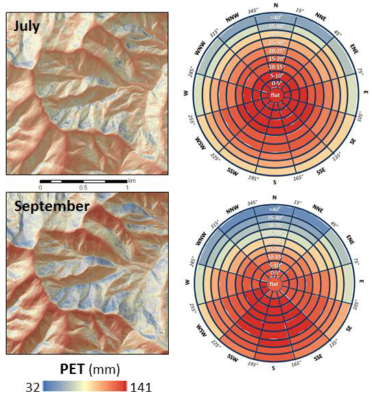
| Potential evapotranspiration modeled
at Asheville NC, using the Water Balance Toolbox.
Circular charts show how average PET varies with slope
and aspect throughout the year. Aspect is
represented along the circumference, and slope
steepness increases from the center to the edges of
the circles. |
 |
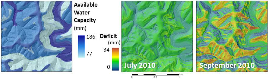 |
Available water capacity (top 1 meter of soil) and monthly deficit for the Vinton Furnace Experimental Forest (Vinton County, OH), modeled with the Water Balance Toolbox. |
ArcGIS provides a “Solar Radiation” toolset that can compute monthly values of total (global) radiation for each pixel in a DEM, based on slope, aspect, topographic shading, latitude, and time of year. The user must specify two atmospheric parameters: the diffuse proportion of global radiation, and transmittivity (the proportion of solar radiation outside the atmosphere that reaches the surface). The toolset’s default values for these parameters are 0.3 and 0.5, respectively. These values can assume a wide range of values, however. In the eastern US, I have observed 21 different combinations, with monthly values of diffuse proportion between 0.2 – 0.7, and transmittivity values between 0.3 – 0.7. Misspecifying these values can have profound effects on radiation estimates. Since additional factors, such as surface reflectance or altitude, may affect radiation at a site, I adopt the approach of adjusting the two values to best approximate a “known” radiation value.
Maps of suggested monthly Diffuse Proportion and Transmittivity values for the eastern U.S., based on monthly radiation estimates obtained from the National Solar Radiation Database.
Excel spreadsheet for determing "best" diffuse proportion and transmittivity values for ArcGIS Solar Radiation tool, used in conjunction with "Guidelines for parameterizing the diffuse proportion and transmittivity values for ArcGIS Solar Radiation tool."
Moisture Demand (PET) is governed by temperature and radiation. But by using a monthly time-step, diurnal variations in temperature are not considered. The result is that maximum PET occurs on southern exposures, since that is where maximum insolation occurs (and PET is symmetrical about the N-S axis). To overcome this, the Water Balance toolset employs “adjustment coefficients” that either increase or decrease PET based on topographic position. The user has the option of using PET Adjustment Coefficients derived for four sites in the eastern U.S., or generating his/her own coefficeints using these guidelines. Alternatively, this adjustment can be omitted, allowing maximum PET to occur on southern aspects.
Excel spreadsheet for deriving daily water balances, used in conjunction with "Guidelines for creating PET Adjustment Coefficients."
Daily PET Toolbox for creating adjustment coefficients
The National Renewable Energy Laboratory provides solar radiation estimates for the U.S. at 10-km resolution, and "Typical Meteorological Year" radiation data. Hourly estimates of global horizontal radiation can be summed to provide a monthly total, which will be directly comparable to monthly estimates derived from the Solar Radiation Toolset. See the information under "Guidelines for parameterizing the diffuse proportion and transmittivity values for ArcGIS Solar Radiation tool" above.
In the U.S., soil water-holding capacity is available from the Natural Resources Conservation Service's Web Soil Survey. Detailed instructions on downloading and preparing soil available water capacity (AWC) grids are provided in Appendix A of the User Manual (above).Digital Elevation Models
DEMs are available for many locations at ⅓-arc second (~10 m) resolution (or finer) from the U.S. Geological Survey’s National Map Viewer.
The DEMs that you download will have elevation in meters, with a Geographic Coordinate System (NAD83) projection (units = degrees). Thus, the x, y, and z values will be in different units. You will need to reproject the grid to a "meter-based" projection (such as Plate Carree (world), or UTM). Part II of "Guidelines for parameterizing the diffuse proportion and transmittivity values for ArcGIS Solar Radiation tool" provides sample instructions
for downloading and projecting DEMs.
Climate data for individual stations (including climate normals) are available from the National Climatic Data Center.
Gridded monthly temperature and precipitation data are available for the U.S. at 30-arc second (~800 m) resolution from the PRISM Group.
After downloading and unzipping the ".asc" grid, use ArcGIS's ArcToolbox – Conversion Tools – To Raster – ASCII to Raster. The new grid will be in Geographic Coordinate System - Spheroid-Based - GRS 80 (ArcToolbox – Data Management Tools – Projections and Transformations – Define Projection).