|
|
James Dyer Professor Ph.D., University of Georgia |

| Contact Information |
e-mail: phone: fax: mailing address: |
dyer@ohio.edu 740.593.1142 740.593.1139 Department of Geography Lindley Hall N266 Ohio University Athens OH 45701  |
Jump to: | Downloads
[Water Balance Toolbox, Shapefiles of Forest Regions and Ohio Hemlock, Historic Land Use Maps for the Eastern U.S., Maps of Ridges Land Lab at Ohio University] Videos:
Research Projects Publications Graduate Student Theses Courses I Teach |
| Downloads |
Water
Balance Toolbox for ArcGIS and User Manual FULLY-AUTOMATED VERSION 3 NOW
AVAILABLE (You may need to refresh your browser).
from Dyer, J.M. 2019. A
GIS-based water balance approach using a LiDAR-derived
DEM captures fine-scale vegetation patterns. Remote
Sensing 11(20): 2385.
Revised Map of Braun's Forest Regions (image and ArcGIS shapefile) from Dyer, J.M. 2006. Revisiting the
Deciduous Forests of Eastern North America. BioScience 56: 341-352.
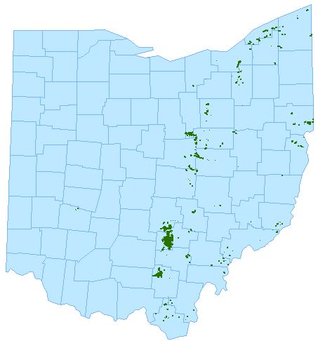
Distribution Map of Ohio Hemlock (ArcGIS shapefile created by Nicole Stump) Historic Land Use Maps for the Eastern U.S. Maps of the Ridges Land Lab Orthophotographs,
historic air photos, land cover maps, trails &
contour maps for Ohio University's Land Lab
|


| Publications Google Scholar Click here to view abstracts |
|
Knisely, J.K., and J.M. Dyer. 2024. Southeastern Ohio
hemlock stands prior to hemlock woolly adelgid
infestation: Baseline conditions from 2 surveys a decade
apart. The Ohio Journal of Science, 24(2): 2-22.
https://doi.org/10.18061/ojs.v124i2.9739
Supplemental Excel data file: https://kb.osu.edu/handle/1811/105365 D’Orangeville, L., M. Itter, D. Kneeshaw, J.W. Munger, A.D. Richardson, J.M. Dyer, D.A. Orwig, Y. Pan, and N. Pederson. 2021. Peak radial growth of diffuse-porous species occurs during periods of lower water availability than for ring-porous and coniferous trees. Tree Physiology, tpab101, https://doi.org/10.1093/treephys/tpab101 Hutchinson, T.F., and J.M. Dyer. 2021. American Chestnut in Ohio’s Historic Woodlands. Ohio Woodland Journal, 28(3): 16. Dyer, J.M. 2019. A GIS-based water balance approach using a LiDAR-derived DEM captures fine-scale vegetation patterns. Remote Sensing 11(20): 2385. https://doi.org/10.3390/rs11202385 Iverson, L.R.; J.L. Bartig, G.J. Nowacki, M.P. Peters, J.M. Dyer, T.F. Hutchinson, S.N. Matthews, and B.T. Adams. 2019. USDA Forest Service Section, Subsection, and Landtype Descriptions for Southeastern Ohio. Research Map NRS-10. Newtown Square, PA: U.S. Department of Agriculture, Forest Service, Northern Research Station. 68 p. [Printed map included]. https://doi.org/10.2737/NRS-RMAP-10. Dyer, J.M., and T.F. Hutchinson. 2018. Topography and soils-based mapping reveals fine-scale compositional shifts over two centuries within a central Appalachian landscape. Forest Ecology and Management, 433: 33-42. https://doi.org/10.1016/j.foreco.2018.10.052. Pederson, N., A.W. D'Amato, J.M. Dyer, D.R. Foster, D. Goldblum, J.L. Hart, A.E. Hessl, L.R. Iverson, S.T. Jackson, D. Mario-Benito, B.C. McCarthy, R.W. McEwan, D.L. Mladenoff, A.J. Parker, B. Shuman, and J.W. Williams. 2015. Climate remains an important driver of post-European vegetation change in the eastern United States. Global Change Biology, 21(6): 2105-2110. Pederson, N., J.M. Dyer, R. McEwan, A. Hessl, C. Mock, D. Orwig, H. Rieder, and B. Cook. 2014. The legacy of episodic climatic events in shaping temperate, broadleaf forests. Ecological Monographs 84(4): 599-620. Anning, A., J.M. Dyer, and B.C. McCarthy. 2014. Tree growth response to fuel reduction treatments along a topographic moisture gradient in mixed-oak forests, Ohio, USA, Canadian Journal of Forest Research 44(5): 413-421. McEwan, R.W., J.M. Dyer, and N. Pederson. 2011. Multiple interacting ecosystem drivers: toward an encompassing hypothesis of oak forest dynamics across eastern North America. Ecography 34: 244-256. Dyer, J.M. 2010. Land use legacies in a central Appalachian forest: Differential response of trees and herbs to historic agricultural practices. Applied Vegetation Science 13: 195-206. Dyer, J.M. 2009. Assessing topographic patterns in moisture use and stress using a water balance approach. Landscape Ecology 24: 391-403. ArcGIS toolbox & user manual available as Download Dyer, J.M., and C.M. Cowell, 2008. Invasive Species and the Resiliency of a Riparian Environment. Pages 87-103 in R.K. Kohli and S. Jose (eds.) Invasive Plants and Forest Ecosystems. CRC Press, Boca Raton, FL. Dyer, J.M. 2006. Revisiting the Deciduous Forests of Eastern North America. BioScience 56: 341-352. Shapefile & image available as Download Dyer, J.M. 2004. A water budget approach to predicting tree species growth and abundance, utilizing paleoclimatology sources. Climate Research 28: 1-10. Dyer, J.M. 2002. A comparison of moisture scalars and water budget methods to assess vegetation-site relationships. Physical Geography 23: 245-258. Cowell, C.M., and J.M. Dyer. 2002. Vegetation development in a modified riparian environment: Human imprints on an Allegheny River Wilderness. Annals of the Association of American Geographers 92: 189-202. Dyer, J.M. 2001. Using witness trees to assess forest change in southeastern Ohio. Canadian Journal of Forest Research, 31: 1708-1718. Dyer, J.M., and K.E. Moffett. 1999. Meadow invasion from high-elevation spruce-fir forest in south-central New Mexico. The Southwestern Naturalist 44: 445-457. Dyer, J.M., and P.R. Baird. 1997. Remnant forest stands at a prairie ecotone site: presettlement history and comparison with other maple-basswood stands. Physical Geography 18: 146-159. Dyer, J.M., and P.R. Baird. 1997. Wind disturbance in remnant forest stands along the prairie-forest ecotone, Minnesota, U.S.A. Plant Ecology 129: 121-137. Click here to see simulation of species migration in response to climate change Pitelka, L.F., and The Plant Migration Workshop Group. 1997. Plant migration and climate change. American Scientist 85: 464-473. Dyer, J.M. 1996. Considerations of scale and ecological processes in a forest migration model: a reply to Roth. Professional Geographer 48: 86-88. Dyer, J.M. 1995. Assessment of climatic warming using a model of forest species migration. Ecological Modelling 79: 199-219. Dyer, J.M. 1994. Implications of habitat fragmentation on climate change-induced forest migration. Professional Geographer 46: 449-459. Dyer, J.M. 1994. Land use pattern, forest migration, and global warming. Landscape and Urban Planning 29: 77-83. Dyer, J.M., and G.A. Brook. 1991. Spatial and temporal variations in temperate forest soil carbon dioxide during the non-growing season. Earth Surface Processes and Landforms 16: 411-426. |
| Graduate and Honors
Student Theses I've Advised Click here to view abstracts |
|
Eastern Hemlock (Tsuga
canadensis) Forests of the Hocking Hills Prior to
Hemlock Woolly Adelgid (Adelges tsugae)
Infestation, Jordan Knisely, Environmental Studies,
Honors Tutorial College BA 2021. [Link
to PDF] Landscape Effects on Urban Plant Traits: Rethinking the Value of Urban Weeds, Dani Niziolek, Geography and Environmental Studies, Honors Tutorial College BS 2020. [Link to PDF] Mapping a Deciduous Forest: Utilizing an Unmanned Aerial Vehicle to Track Phenology, Jonathan Hogue, Geography MS 2018. [Link to PDF] Examining the Cover and Composition of the Successional Vegetation Mosaic of Pre-SMCRA Mined Landscapes in Southeast Ohio, Gary Conley, Geography MS 2013. [Link to PDF] American Chestnut Restoration in Eastern Hemlock-Dominated Forests of Southeast Ohio, Nathan Daniel, Environmental Studies MS 2012. (co-advisor: Brian McCarthy) [Link to PDF] Spatial Distribution of Freshwater Mussels (Unionidae) in Ohio Brush Creek Watershed, Southern Ohio, Jason K. Brown, Geography MA 2010. [Link to PDF] Microclimatic and Topographic Controls of Fire Radiative Energy in Southeastern Ohio, Loredana G. Suciu, Geography MA 2009. [Link to PDF] Ecological Considerations for Risk Management of the Hemlock Woolly Adelgid in the Hocking Hills, Ohio USA, Nicole Stump, MSc 2008 (Albert-Ludwigs University). Download: zipped shapefile or jpeg of hemlock distribution in Ohio, methods and results of GIS mapping from thesis (PDF), PDF of 2009 HWA Summit presentation. Using Landscape Variables to Assess Stream Health in Ohio’s Western Allegheny Plateau, Lisa King, Geography MA 2008. [Link to PDF] Predicting Infestations of Hemlock Woolly Adelgid (Adelges tsugae) in Great Smoky Mountains National Park Tennessee/North Carolina, USA, Scott Snider, Geography MA 2004. [Link to PDF] Exotic Plant Colonization of the Forest Adjacent to Transmission Line Corridors in Athens County, Ohio, Kaabe Shaw, Environmental Studies MS 2002. Linking Spatial Data with Population Viability Analysis: Reserve Network Design in the Northeastern Ecuadorian Amazon, Galo Zapato-Rios, Environmental Studies MS 2001. Land Use Land Cover Change From 1915 to 1999 in The Gwynns Falls Watershed, Baltimore County, Maryland: Creation of a Suburban Social Ecology, Michael Wehling, Geography MA 2001. Click here to view a summary with figures. The Biogeography of Gapper's Red-backed Vole (Clethrionomys gapperi): A Comparison of Genetic and Morphological Variation in Landscape Suitability: A Case Study of Wolf Habitat in Catastrophic Windthrow: A Case Study of the A Spatial Analysis of an Urban Fishery: A Case Study of |
| |
|
 |
|
| |
|||
| Courses I Teach | Click on course title for syllabus
from most-recent offering |
||
| GEOG 1100: | Physical Geography (fall semester) | ||
| GEOG 2710: | Intro to Statistics in Geography (spring) | ||
| GEOG 3160/5160 (BIOS 3160/5160): | Biogeography (spring) | ||
| GEOG 4170/5170: | Landscape Ecology |
||
| GEOG 3712/5712: | Geographic Field Methods (fall) | ||
| GEOG 4799: | Foundations for Capstone Research (spring) | ||
| GEOG 4800: | Capstone Experience in Geography (fall) | ||
| GEOG 6160: | Seminar in Biogeography | ||
Last Updated November 2024